Image Maps in TEI
Oxygen XML Author includes support for image maps in TEI documents through
the use of the <facsimile> element. In TEI documents, this feature provides an
easy way to create areas (using <zone> elements) in an image where the end-user
can hover or click to retrieve more information about that particular area of the image. The
visual Author editing mode includes an Image Map
Editor that helps you to easily create the areas in the image.
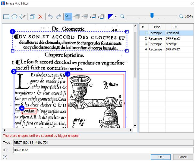
Image Map Editor Interface in TEI
- Toolbar
-
 New
Rectangle
New
Rectangle- Use this button to draw a rectangular shape over an area in the image. You can drag any of the four points to adjust the size and shape of the rectangle.
 New
Polygon
New
Polygon- Use this button to draw a polygon shape over an area in the image. This action opens a dialog box that allows you to select the number of points for the polygon. You can drag any of the points to adjust the size and shape of the polygon.
 New Free Form
Shape
New Free Form
Shape- Use this button to draw a free form shape over an area in the image. After selecting this button, left-click anywhere in the image to place the first point of your shape. Then move the cursor to the location of the next desired point and left-click to place the next point, and so on. To complete the shape (area), click the first point again and a line will automatically be added from the last point that was added, or simply double-click the last point to automatically add the line from the last point back to the first.
 Duplicate
- Use this button to create a duplicate of the currently selected shape.
 Delete
- Use this button to delete the currently selected shape.
 Undo
Undo- Use this button to undo the last action.
 Redo
Redo- Use this button to redo the last action that was undone.
 Show/Hide
Numbers
Show/Hide
Numbers- Use this button to toggle between showing or hiding the numbers for the shapes.
 Bring Shape to
Front
Bring Shape to
Front- Use this button to bring the currently selected shape forward to the top layer.
 Bring Shape
Forward
Bring Shape
Forward- Use this button to bring the currently selected shape forward one layer.
 Send Shape
Backward
Send Shape
Backward- Use this button to send the currently selected shape back one layer.
 Send Shape to
Back
Send Shape to
Back- Use this button to send the currently selected shape back to the bottom layer.
 Color
Chooser
Color
Chooser- Use this drop-down menu to select a color scheme for the lines and numbers of the shapes.
 Zoom
Slider
Zoom
Slider- Use this slider to zoom the image in or out in the main image pane.
- Image Pane
-
This main Image Pane is where you work with shapes to add hyperlinks to multiple areas within an image. The editing mechanisms that are supported in the Image Pane include the following:
-
- Mouse Controls and Keyboard Shortcuts
-
- Use the mouse to select and move shapes around in the image pane. It is easy to see which shape is selected in this image pane because the border of the selected shape changes from a solid line to a dotted one.
- You can also drag any of the points of a selected shape to adjust its size and shape.
- You can hold down the Ctrl key to select multiple shapes and then move them simultaneously.
- You can also move shapes by using the arrow keys on your keyboard. In addition, you can hold down Shift while using the arrow keys to move the shape further or Alt to move it 1 pixel at a time.
- To zoom in or out, you can use the NumPad + or NumPad - keys respectively. Use Ctrl + NumPad 0 to reset the zoom level to its default value.
- You can use Ctrl + Z to undo an action or Ctrl + Y to redo the last action that was undone.
- Contextual Menu Actions
-
You can right-click the shapes, points, or anywhere in the Image Pane to invoke the contextual menu where the following actions are available:
 Add Point
- Adds a point to Polygon or Free Form shapes.
 Remove Point
- Removes the current point from Polygon or Free Form shapes.
- Duplicate
- Create a duplicate of the currently selected shape.
- Delete
- Delete the currently selected shape.
- New
Rectangle
- Creates a rectangular shape over an area in the image. You can drag any of the four points to adjust the size and shape of the rectangle.
- New
Polygon
- Creates a polygon shape over an area in the image. This action opens a dialog box that allows you to select the number of points for the polygon. You can drag any of the points to adjust the size and shape of the polygon.
- Undo
- Use this action to undo the last action.
- Redo
- Use this action to redo the last action that was undone.
- Shape Table
- The table at the right of the Image Pane is a sequential list of all the areas (shapes) that have been added in the image. It shows their number, type, and ID. If you select one of the entries in the table, the corresponding shape will be selected in the Image Pane.
- Properties
-
- Type
- Displays information about the selected coordinate.
- ID
- The identifier for the selected area. This will become the value of the
@xml:idattribute for the particular<zone>element. When you insert a new zone, a unique ID is automatically generated and displayed in this field. However, you can change this value if you want to.
How to Create an Image Map in TEI
- The image (
<graphic>) must be inside a<facsimile>element to support the Image Map Editor feature. -
Right-click the image and select Image Map Editor.
Step Result: This action will apply an image map to the current image and open the Image Map Editor dialog box.
- Add areas (zones) in the image by selecting one of the shape buttons
(
 New Rectangle or
 New Polygon).
 - Move the shape to the desired area in the image and drag any of the points on the
shape to adjust its size or form. You can use the other buttons on the toolbar to adjust its layer and color, or to
perform other editing actions.Tip: You can right-click any of the points, shapes, or anywhere in the Image Pane to access various helpful contextual menu actions. For example, the easiest way to remove a point is to right-click the point and select
 Remove
Point.
Remove
Point. - With the shape selected, enter an ID.
- If you want to add more areas (zones) to the image, select a shape button again and repeat the appropriate steps.
- When you are finished, click OK to process your changes.
- Image Map Editor - Click this button to open the Image Map Editor.
- Image Map Details - Click this button to expand a section that displays the details of the image map.
How to Edit an Existing Image Map in TEI
- Simply double-click the image.
- Right-click the image and select Image Map Editor.
- Click the Image Map Editor button below the image.
You can also click the Image Map Details button below the image to expand a section that displays the details of the image map and allows you to change the coordinates and IDs of the hyperlinked areas.
<zone> elements contain additional
content (such as text or comments) and you edit the image map, the Image Map
Editor does not preserve the additional content. Therefore, if you do need
to insert additional content inside the <zone> elements, you should do so
after the image map has been created and finalized. Subsequent changes to the image map
should then be done in Text mode.Overlapping Areas
If shapes overlap one another in the Image Map Editor, the one on
the top layer takes precedence. The number shown inside each shape represents its layer (if
the numbers are not displayed, click the  Show/Hide Numbers button on the Image Map Editor toolbar). To change the layer
order for a shape, use the layer buttons on the Image Map Editor toolbar (
Show/Hide Numbers button on the Image Map Editor toolbar). To change the layer
order for a shape, use the layer buttons on the Image Map Editor toolbar ( ,
,  ,
,
 ,
,  ).
).
If you insert a shape and all of its coordinates are completely inside another shape, the Image Map Editor will display a warning to let you know that the shape is entirely covered by a bigger shape. Keep in mind that if a shape is completely inside another shape, its hyperlink will only be accessible if its layer is on top of the bigger shape.